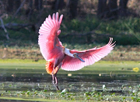
Nothing like a few dozen Roseate Spoonbills (Ajaja ajaja; syn. Platalea ajaja) to brighten an otherwise dreary, warm and buggy Florida afternoon.

Above: A young White Ibis (Eudomicus albus) with a Roseate Spoonbill.
These wading birds have a long, flat spoon-like bill. Adults are shell-pink with a blood-red "drip" on the shoulders, and an orange tail. I think they look quite goofy up-close.

Spoonbills are gregarious, often staying together as a flock. They stick their bill into shallow water and swing it side to side while walking through the water. The spoon-shaped bill allows it to sift easily through mud.

They feed on crustaceans, aquatic insects, frogs, and very small fish ignored by larger waders.

The Spoonbill nests in shrubs or trees. In Central Florida it would be quite unusual to find a nesting pair, more likely they are only passing through to get to a much less populated area like the Merritt Island National Wildlife Refuge to our east.

The Roseate Spoonbill is a resident breeder in South America mostly east of the Andes. Its also found in smaller numbers in coastal regions of the Caribbean, Central America, Mexico, and the Gulf Coast of the USA.

The Bird averages 71–86 cm (28–34 in) long, with a 120–130 cm (47–51 in) wingspan and a body mass of 1.2–1.8 kg (2.6–4.0 lb).

Like the American Flamingo (Phoenicopeterus ruber), their pink color is diet-derived, consisting of the carotenoid pigment canthaxanthin.

The colors can range from pale pink to bright magenta, depending on age and location. Unlike herons, spoonbills fly with their necks outstretched. They alternate groups of stiff, shallow wingbeats with glides. Above: Two spoonbills are to the right of the image. To the left the group of white birds are American White Pelicans (Pelecanus erythrorhynchos). Look really close and you can see a Caracara (Northern Crested Caracara; Caracara cheriway) in the tree in the background.
Click on any image to enlarge.

Above: To the right is a Great Blue Heron (Ardea herodias), two Great Egrets (Ardea alba) are in the background.

Without rain soon there won't be any water left for these birds, or any others. Good thing they can fly on to coastal regions where there are tidal wetlands.

The only noise I heard them make was a low grunting croak. Nothing like a song or any other kind of communication. Perhaps since they stay so close to their peers they don't need to say much.

TROPICAL STORM SEAN TO BECOME A HURRICANE

After drifting toward us today, Sean has taken a turn for the north. The National Hurricane Center is predicting that Sean will become a hurricane later today.
In the image above I highlighted the coming cold front that is going to pick up Sean and push him quickly to the northeast, out to sea. The trough (or cold front) could bring the center of Sean close enough to Bermuda to bring the island some much-needed heavy rain squalls and sustained winds of 40-45 mph.
Very high wind shear will likely destroy Sean on Friday.
The storm brought some blustery winds from the northeast to the east coast of Florida today. It was odd in that it was still quite warm and buggy but in the breeze the bugs were tolerable. Once I got out of the breeze the mosquitoes swarmed me by the thousands. I was flailing like a mad man trying to get my keys and get into the shelter of car and then house to escape the hungry bugs.
The cold front should give us some relief from the bugs for at least a couple of days (Friday and Saturday), but it is not forecast to bring with it any rain.

Rolf Hits France's Côte d'Azur
The largest cities in the region are Marseille, Nice, Toulon, and Aix-en-Provence.
Above and Below: High waves this week in the southern French city of Nice. Heavy rain and flooding hit southern France with hundreds of people evacuated and at least three killed in flood-related accidents. In Var, one of the worst-hit regions, more than 1,600 people were evacuated or assisted by authorities and about 3,900 homes were without electricity.
The storm produced heavy rains, hurricane-force winds gusts, and significant coastal flooding. The storm began over the weekend as an extratropical storm, but then stalled out over the relatively warm waters of the Mediterranean, acquiring tropical characteristics. Heavy thunderstorms similar in intensity to what one would get in a tropical storm built up, and Rolf developed sustained winds above tropical storm force.
Above: Port de Cannes, big waves (or "heavy swell," grosse houle en française).
These sort of hybrid extratropical/tropical storms that form over waters colder than 22°C can cause substantial damage. Rolf brought heavy rains in excess of 400 mm (15.7") over the past 4 days to the department of Var, north of Toulon. A wind gust of 95 mph was recorded at 21 UTC November 8 at Porquerolles Island, south of the city of Toulon. French radar shows heavy rains from Rolf are continuing to affect Southeast France and the island of Corsica. Water temperatures off the south coast of France are near 17°C (63°F), far below the 26°C threshold usually needed to sustain a tropical storm.
See more video at Corsica's Daily Newspaper: Corsematin.com
Visit


No comments:
Post a Comment