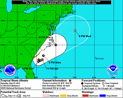
Tropical Storm Alberto formed this afternoon off the coast of South Carolina on Saturday from the remnants of an old frontal boundary that had been draped across Florida last week.
Alberto has the potential to hit North Carolina as early as Monday, but will likely stay offshore. Regardless, the storm is small, thus it would only affect a small area of the coast with high winds and heavy rain were it to directly impact North Carolina.
Upper level winds out of the southwest are creating a moderate 15 - 20 knots of wind shear over Alberto, and the storm is over the warm waters of Gulf Stream, which are 81° F (27° C), just above the 26° C threshold typically needed to sustain a tropical storm.
Alberto is tangled up with an upper level trough of low pressure, which is pumping cold, dry air into the storm, slowing development. The dry air impinging on Alberto from the southwest can be seen in water vapor satellite loops. Heavy rain showers from Alberto are located about 50 miles offshore of the coast of South Carolina, as seen on Wilmington radar. At times yesterday Alberto had a cloud-free center resembling an eye on radar, but this was not a true eye.
Forecast for Alberto
Rain showers from Alberto are likely to move onshore between Charleston and Wilmington today, bringing 1 - 3 inches of rain to portions of the coast. The storm is too small to cause major flooding problems, particularly since the coast is experiencing moderate to severe drought.
Alberto's rains will not be plentiful enough to cause significant drought relief, except perhaps over a small region near the coast, where (and if) the storm makes landfall. Wind shear is expected to remain in the moderate range, 15 - 20 knots, through Monday, which is low enough to allow some slow development.
Since the storm is very small, it is highly vulnerable to even a modest increase in wind shear or dry air, which could rapidly dissipate the storm. Steering currents are weak, and Alberto will wander off the coast of South Carolina through Sunday, before getting caught up by a trough of low pressure on Monday which should lift the storm out to the northeast. The moderate wind shear and dry air are likely to keep Tropical Storm Alberto below hurricane strength. The National Hurricane Center is forecasting a 5 - 10% chance of Alberto reaching hurricane strength before dissipating on Thursday as it speeds northeast out to sea.
Alberto in historical context
Alberto is earliest-forming tropical storm in the Atlantic Basin since Ana in 2003, which formed on April 21. Alberto is one of only three Atlantic tropical storms to form in May in the past 31 years.
The others were Tropical Storm Arthur of 2008, and Tropical Storm Arlene of 1981. There was also a subtropical storm, Andrea, that formed in May of 2007 in more or less the same location as Alberto (above). Formation of an early season tropical storm from an old frontal boundary, like occurred with Alberto, is not a harbinger of an active hurricane season—it is a random occurrence. Early season storms that form in the Caribbean, however, often signal that a busy hurricane season to follow.


