
"Category 7" Hurricane Patricia has become the strongest hurricane ever tracked by the National Hurricane Center in either the Atlantic or eastern Pacific basins with wind speeds of 200 mph and wind gusts upwards of 245 mph. The west coast of Mexico south of Puerto Vallarta is set to take a direct hit from this extremely dangerous hurricane later tonight. The states of Colma and Jalisco and particularly the towns of Manzanillio, Colima, Autlá, Tecomán, and Ciudad Guzmán are expected to see catastrophic conditions. Depending on the exact landfall location the area around Guadalajara could also experience hurricane conditions and catastrophic flooding. The remnants of Patricia will quickly make their way over northern Mexico and into the Gulf of Mexico, where they will aid in producing torrential rainfall for Texas as a new cyclone forms off the Texas Gulf coast.
Manzanillo is located at 19.05 N, 104.31 W. At noon, October 23, 2015, the storm was forecast to make landfall around 19.8 N., 105.1 W. or in the general vicinity of Manzanillo with 200 mph winds.
 |
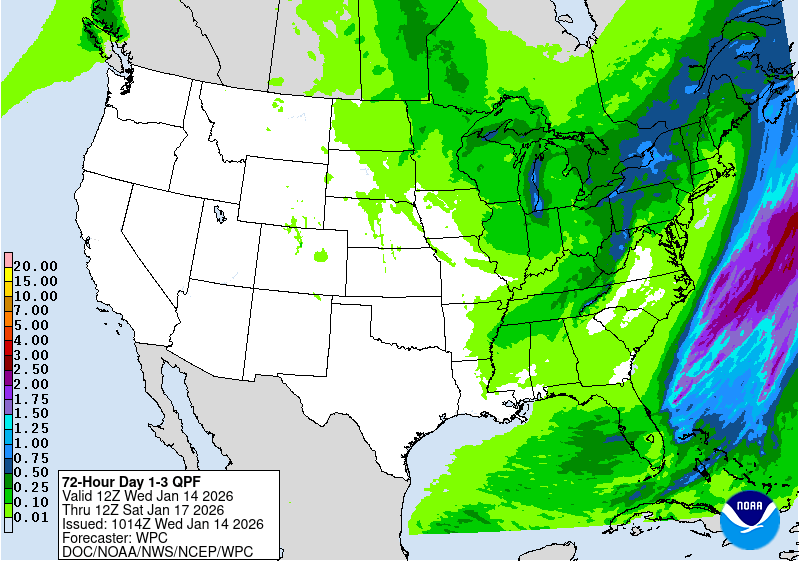
| Rainfall Forecast for Texas Flood October 25-27th, 2015 |
Patricia Becomes one of Few
"Category 7" Storms
Ever Recorded
The Saffir-Simpson Hurricane Wind scale rates hurricanes on a scale of 1-5, depending on the maximum sustained winds. The strongest hurricanes, categorized as category 5 storms, produce maximum sustained winds exceeding 155 mph, and inflict catastrophic wind damage. However, one limitation to this bounded scale is that hurricanes with winds of 160 mph and 200 mph are both classified as category 5 storms. Perhaps that will change as Earth warms and intense storms become more common. We're suggesting extending the scale to Cat. 6 and 7. For now the National Hurricane Center refers to the strongest storms as "Major" hurricanes.
If the Saffir-Simpson Hurricane Wind scale were a continuous scale, with no upper bound, Patricia might be classified as a category-7 hurricane. Considering that category-3 hurricanes produce winds of 115-135 mph, and cat 4 hurricanes produce winds of 135-155 mph, if we continued using 20 mph wind categories, cat 5 hurricanes would be categorized 155-175 mph, cat 6 hurricanes 175-195 mph, and rare cyclones like Patricia and Super Typhoon Haiyan, which impacted the Philippines in 2013, could be classified as cat-7 tropical cyclones, with winds exceeding 195 mph.

Stunning Storm
Stunning, historic, mind-boggling, and catastrophic are how some have described Hurricane Patricia, which intensified to an incredible-strength Category 5 storm with 200 mph winds overnight. At 2:46 am EDT October 23, 2015 an Air Force hurricane hunter aircraft measured a central pressure of 880 mb in Patricia, making it the most intense hurricane ever observed in the Western Hemisphere. The aircraft measured surface winds of 200 mph, which are the highest reliably-measured surface winds on record for a tropical cyclone, anywhere on the Earth. The previous strongest Eastern Pacific hurricane was Hurricane Linda of 1997, with a pressure of 902 mb (estimated from satellite imagery). The strongest Atlantic hurricane on record was Hurricane Wilma of 2005, with an 882 mb central pressure. Patricia does not beat the record-lowest pressure in the Western Pacific, though, which is held by Super Typhoon Tip of 1979: 870 mb.

Patricia is also the fastest-intensifying Western Hemisphere Hurricane on Record
Patricia's central pressure dropped an astonishing 100 mb in 24 hours, making it the fastest-intensifying hurricane ever observed in the Western Hemisphere. Patricia's pressure at 5 am EDT Thursday, October 22, 2015 was 980 mb, and was 880 mb at 5 am EDT Friday. The previous record was a drop of 97 mb in 24 hours for Hurricane Wilma of 2005 (between 1200 UTC 18 October - 1200 UTC 19 October), according to the official NHC report for the storm. Patricia's intensification rate was very close to the WMO-recognized world record for fasting-intensifying tropical cyclone: 100 millibars in just under 24 hours by Super Typhoon Forrest in the Northwest Pacific in 1983.
Patricia is estimated to have intensified 85 knots (100 mph) in 24 hours, from a tropical storm to a Category 5 hurricane. In the Eastern Pacific, Hurricane Linda of 1997 is the only storm on record to have intensified at this rate. The Atlantic's record holder for largest wind increase in 24 hours is held by Hurricane Wilma of 2005, which intensified from a 60-knot tropical storm to a 150-knot Category 5 hurricane--an increase of 90 knots (105 mph). Air Force reconnaissance observations indicated that the eye of Wilma contracted to a diameter of 2 n mi during this time; this is the smallest eye known to National Hurricane Center (NHC) staff. Patricia's eye diameter was 8 miles at it's peak strength.

Forecast for Patricia:
Manzanillo at dire risk
Satellite loops early Friday afternoon showed that Patricia’s cloud tops had begun to warm, indicating weakening, and with wind shear now a moderate 10 - 20 knots and interaction with land beginning to occur, Patricia will likely weaken to 155 - 175 mph winds by landfall. The storm's expected turn toward the northeast has begun, and the storm is beginning to accelerate toward the coast of the Mexican state of Colima.
At particular risk is the city of Manzanillo, a regional center that straddles the back of a bay spanning several miles. On its current track, it appears that Patricia could make landfall sometime between 6:00 and 10:00 pm EDT just to the northwest of Manzanillo—a trajectory that raises the odds of a catastrophic storm surge in or near Manzanillo. Patricia’s strongest winds are confined to a relatively small area, with hurricane-force winds only spanning a range of 30 miles from Patricia’s center. Category 5 winds of 156+ mph cover an area 15 miles across. Wherever those winds are focused, we can expect gigantic waves atop a devastating surge. An unnamed 1959 hurricane—the deadliest in Northeast Pacific history, with an estimated 1800 direct and indirect fatalities—struck near Manzanillo on October 27 (see embedded YouTube newsreel footage below). Storm surge expect Dr. Hal Needham says he expects a storm surge of 16.5 ft (5 m), which will be accompanied by large, destructive waves. This would be the largest storm surge in the modern history of Western Mexico.

After landfall, Patricia will slam into very rugged terrain, triggering torrential rains with the risk of severe flooding and mudslides. The mountainous trek will shred Patricia’s low-level circulation quickly, but the hurricane’s upper-level circulation will proceed quickly northeastward, arriving near South Texas by Sunday. Models suggest that a nontropical or hybrid low-pressure center may develop near the upper-level center at that point. Patricia’s presence will exacerbate a multi-day rain/flood episode already under way across Texas, with widespread 4” - 8” rainfall amounts across the eastern half of the state expected between now and Monday. Localized totals well over a foot are quite possible.
 |
| Houston-Galveston Flood Warnings for Weekend of October 24-25, 2015 |
Hurricane Patricia-Hurricane Camille Comparison

Some are comparing Hurricane Patricia to Hurricane Camille of 1969. Camille's wind field was larger but in other ways the storms do appear similar. I rode out Camille as a small child 90 miles north of the storm, and in 1969 we were trapped for weeks in a devastated post-Camille Mississippi. Similar destruction is forecast for Mexico. My essay for the Orlando Sentinel about my Hurricane Camille recollections below:
Hurricane Changed Look Of The South
By Phillip Lott Special to the Orlando Sentinel
I am one of those unusual individuals who enjoy the sights and sounds of hurricanes. I put myself into harm's way whenever the opportunity presents itself, rather than doing the rational thing: fleeing. I have often wondered what first piqued my interest in such dangerous weather. It was probably my first and most memorable hurricane, Camille. Having chosen Pensacola as our adopted hometown, we have lived through some wicked storms, including Frederick, Erin and Opal. They were notable if only for the utter mess they made. Frederick created 30-foot waves inside Pensacola and Mobile bays. Erin cleaned out all of our oak trees, onto the house. Opal had a tremendous storm surge that destroyed my favorite beach on Santa Rosa Island. It did little damage inland, compared with a much ''weaker'' Hurricane Erin. Erin did cause a last-minute panic when upgraded to a Category 5, which resulted in a traffic jam stretching hundreds of miles, from New Orleans to Montgomery to Tallahassee.
In each storm, power was out for days or weeks. Food spoiled; we were hot and miserable; mosquitos were awful, but none of those storms can compare to Camille. Camille changed the look of the South. It changed the way we view storms, inspired modern radar and hurricane tracking, and destroyed some of my favorite Southern places. My mom, brothers and I were unlucky enough to be right in the path of Camille, and fortunate enough to survive.
I was only 9 in 1969. My family lived in Daytona Beach. We made annual summer trips up to see relatives in Pensacola, Mobile and around Hattiesburg, Miss. That year my father was in Philadelphia on business; my mother had to load me and my two brothers into our old Plymouth Fury by herself for the 15-plus-hour trip to Hattiesburg. Back then, there was no Interstate 10 to whisk you across North Florida. We traveled the winding Routes 40, 17 and 98 across Florida's back country. I remember that it was terribly hot; we were constantly fighting; and my older brother kept complaining that we should not be driving into the path of a killer hurricane. What did he know? We teased him that, because he was a surfer, his brain was surely pickled from the saltwater.
Mom kept saying, ''Your dad would never let us go, knowing a hurricane was coming. I'm sure they exaggerate the reports. Anyway, I lived in Mississippi all my life, and no storm ever bothered us.''
I remember little about Pensacola that year. My paternal grandmother there was disappointed that our father wasn't with us, and she insisted that we continue to Mississippi. Either she didn't know how bad the storm would be, or we were really the monsters that I imagine in my memories of childhood. I remember we were glad finally to reach the long causeway that led across Mobile Bay and the tunnel that signaled the homestretch of our trip into the Deep South. We also noticed that most cars were going the opposite direction, toward Florida.
The ride through Mississippi was uneventful. It was sunny, very hot and steamy. We had no air conditioning in the cars in those days. We arrived in the town of Seminary late in the afternoon to a surprised grandmother, aunts, uncles and cousins. They couldn't believe that we drove in the same day that the century's most powerful hurricane was approaching. Watching the preparations was exciting: windows boarded, water in the tub and gallon jugs, candles burning, batteries, and the radio blaring warnings to evacuate the coast before it was too late.
Mom bundled us in the ''center'' room of my grandmother Leggett's house. The problem was that most Southern houses really don't have a center room, rather a narrow hallway, not big enough for a bunch of excited kids. The sun set as the sky grew tremendously stormy. Around midnight, Camille made its way across my family's little hometown. There, 90 miles north of the coast, Camille's full wrath was delivered.
The pecans were still green on the trees. As the storm approached and the winds picked up, the pecans began to pelt the aluminum siding of Grandmother's little, white house. It sounded as if someone was shooting a .22-gauge shotgun at the house. After the first hour, we couldn't see out the windows anymore. They were plastered with leaves from the pecan, maple and oak trees. Occasionally we would hear something big hit the house, and we would jump, then huddle together again in the hallway. The storm seemed to take forever to pass, hour upon hour of endless wind, horizontal rain and pecans piercing the house. When the eye passed overhead, we all ran out to see the damage. The trees that were still standing were nearly denuded of leaves; trash was everywhere; and above you could see stars in the still sky. Power lines were down everywhere, popping and sizzling, creating a ground-level fireworks display in the still of the eye. We got back inside before the other side of the storm struck.
By morning, Camille had moved on, and Seminary looked nothing like it had the day before. Centuries-old oaks were snapped like toothpicks. Some trees just toppled leaving house-sized roots in the air; houses were gone; cars were upturned; and grandmother's house had changed from white to spring green, covered with the leaves from all the trees. It would take months to clean up the mess.
It was two weeks before we could get a message out of Mississippi that we were OK. Camille had destroyed the state's infrastructure. There was no way to get out to head for home. Few had water or electricity even a month after the storm. I remember that we played in the rubble while the grown-ups worked to clean up the mess. There were showers at the few houses where, miraculously, power and water were operating. Surely for the grown-ups it was a totally miserable time.
Finally, the news reports said that we could travel out of Mississippi, nearly a month after the storm. I remember the causeway across Mobile Bay had been destroyed. The rustic roadside stands were all gone, destroyed by Camille's surge. It was the end of an era. A new, ''hurricane-proof'' Interstate 10 bridge would obliterate one of my favorite stretches of Southern highway. Other, later storms such as Frederick, Erin and Opal would further alter the remaining picturesque towns of the Gulf Coast. Everywhere across the Southern plains of Mississippi and Alabama, there was devastation.
For a kid of 9, it was an exciting time, a wonderfully inspiring experience. I dreamed of being a weather forecaster or a paramedic or a Coast Guardsman. Times were uncomplicated—transistor radios, families huddled together and communities coming together.
We also learned the best hurricane advice one could receive: Flee!