
Above: Gusty winds produce rough seas in Florida as a rainy, windy tropical weather system slogs onshore. The system will combine with a cold front later today, bringing much-needed rain to Central Florida. Read more below.
Below: The leading edge of the dust storm that swamped the Texas Panhandle yesterday.

A powerful cold front pushed through Texas during the afternoon yesterday kicking up a huge dust storm.
Behind the cold front that swept through Texas yesterday, damaging north winds whipped up a dangerous dust storm that cut visibility to near-zero during the afternoon rush hour. Lubbock recorded sustained winds of 48 mph, gusting to 63 mph, with a visibility of 0.2 miles in heavy dust at 5:36 pm CDT.

The dust storm was reminiscent of the great dust storms of the 1930s dust bowl era, and was due to the ongoing exceptional drought. Unfortunately, the front brought no rain to the area.

Lubbock has received just 3.16" (80.26 mm) of rain so far in 2011--more than 13.50" (342.9 mm) below average.

In his Climate Abyss blog, Texas's state climatologist, John Nielsen-Gammon, gives a 25% that the current drought will last five more years. He has an interesting post on how global warming may have affected the drought (or not in his opinion).
It sounds a lot like presidential politics may be forcing him to waffle on previous predictions that the drought could last into the next decade or beyond.
More Rain for Drought Stricken Florida
The same storm system is pushing through Florida this evening and combining with a tropical low pressure system in the Gulf of Mexico, bringing much-needed rainfall.
The large tropical low pressure system off the Florida Gulf Coast, Invest 95L, is currently bringing heavy rains to Southwest Florida.
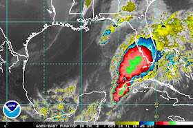
Above: In the current satellite image above notice how Texas remains completely dry while the massive tropical storm system slowly inundates south Florida.
Rainfall amounts in excess of 3 inches (76.2 mm) have been common across South Florida since Saturday; Miami has picked up 3.80" (96.52 mm) as of 9 am EDT this morning, and Key West Naval Air Facility has recorded 14.41" (366 mm).
14.78" (375.41 mm) fell on Sugarloaf Key. Key West has experienced other rain events with far more precipitation; their all-time 24-hour rainfall is 23.28"(591.31 mm), set on November 11, 1980. Interestingly though, this is more rain than fell in the entire year of 1974, when Key West received only 19.99" (507.74 mm).
As the rains have not yet begun to fall in Central Florida . . . and the cold front is already approaching the western panhandle of Florida. . . we can expect to receive less than 2.00" (51 mm) from this latest weather system.
No comments:
Post a Comment