 |
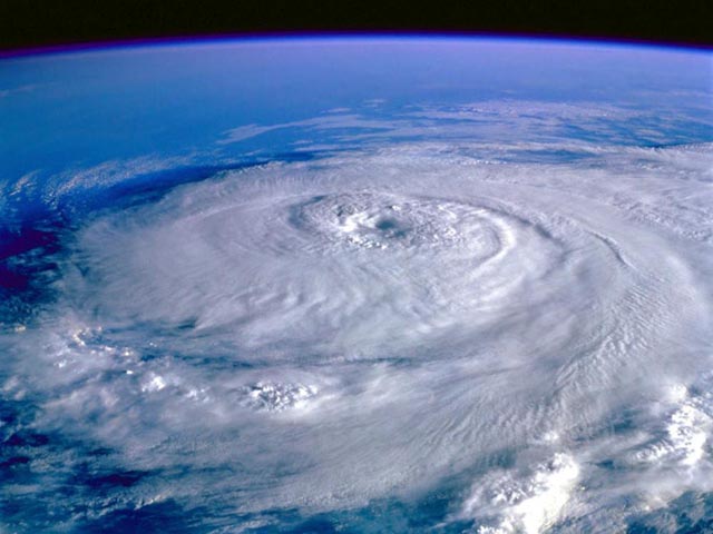
| Perhaps the most spectacular hurricane image ever captured, Hurricane Elena, September 1, 1985 as seen from the Space Shuttle Discovery. At the time, Hurricane Elena was a Category 3 hurricane with 125 mph winds, located only 80 miles offshore from Tampa, Florida. The hurricane prompted the largest mass evacuation in Tampa history.
PHILLIP LOTT PHOTOGRAPHY
on Instagram
Like these photos?
See more at these links
Phillip on twitter
What are the Odds of a Hurricane Hitting Tampa in any Given Year?
While many might think that the odds are high for a hurricane on Tampa—because of its bay front location and because of climate change and global warming—climatology suggest that there is little chance of anything other than typical afternoon thunderstorms this summer, or any summer for that matter.
|
 |
| The gleaming Tampa skyline with the waterfront Convention Center. |
The hurricane evacuation forecast for 2016
Given that there have been only two mass evacuations of Tampa during the past 25 years during the peak three-month period of hurricane season—August, September, and October—history (and climatology) suggest that the odds of a mass evacuation order being given due to weather this summer is probably around one fifth of 1% (00.20%). Miniscule.
 |
| Another view of the Tampa skyline with the bay front Convention Center |
Tampa's Hurricane History
On September 25, 1848, the Great Gale of 1848, the most violent hurricane in Tampa's history, roared ashore as a Category 3 or 4 hurricane with 115 - 135 mph winds. Major R. D. S. Wade weathered the storm in Fort Brooke, in what is now downtown Tampa. Here is what he wrote this to his commanding officer in Washington D.C.:
 |
| Fort Brooke prior to the Great Gale of 1848 |
"The waters rose to an unprecedented height, and the waves swept away the wharves and all the buildings that were near the Bay or river." A 15-foot storm surge was observed at Fort Brooke, and the peninsula where St. Petersburg lies in Pinellas County was inundated "at the waist" and "the bays met," making St. Petersburg an island. After the hurricane, "Tampa was a scene of devastation. Magnificent old oaks were toppled by the hurricane's winds. At Fort Brooke the barracks, horse shed, and other structures were gone. The pine forest north of the garrison was filled with wreckage and debris. The hurricane's powerful surge had shifted sand all along the coast and reshaped many of the keys near Tampa Bay. Navigation routes were filled in and closed, making charts of the area produced before 1848 almost useless after the hurricane. In terms of intensity and destruction, the 1848 storm remains perhaps the greatest in Tampa's history" (Barnes, 1999.)
 |
| Pencil sketch of the Captain's Quarters, drawn by one of the officers stationed at Fort Brooke in 1845. At the time Fort Brooke was one of the largest military establishments in the United States. |
Nothing remains of the fort today, it is buried under the present-day Tampa Bay Convention Center. The convention center is in Evacuation Zone A, which is evacuated for Category 1 hurricanes. The Tampa Bay Times Forum and two major hotels—the Tampa Marriott Waterside and the Embassy Suites—are in Evacuation Zone B, which is evacuated for Category 2 hurricanes. In a worst-case Category 4 hurricane, the Convention Center could be immersed in 20 feet of water. Clearly, even a Category 1 hurricane would be enough to shock the now-nearly 500,000 residents of the Tampa Bay area.
 |
| Predicted height above ground of water from a worst-case Category 4 hurricane in the Tampa Bay region, as computed using NOAA's SLOSH storm surge model (SLOSH is an acronym for "Sea, Lake, and Overland Surges from Hurricanes). The Tampa Bay convention center would be under 20 feet of water, and St. Petersburg would become an island, as previously occurred during the 1848 hurricane. |
Mass Evacuations in Tampa's Modern History
As mentioned above only 2 modern hurricanes have prompted mass evacuations of more than 300,000 people from the Tampa Bay area over the past 25 years. The first was Hurricane Elena of 1985, a Category 3 hurricane that stalled 80 miles offshore for two days on Labor Day weekend, bringing a 6 - 7 foot storm surge, wind gusts of 80 mph, and torrential rains. On August 13, 2004, another mass evacuation was ordered for Hurricane Charley. Thanks to a late track shift, Charley missed Tampa Bay, and instead hit well to the south in Port Charlotte as a Category 4 storm with 150 mph winds. More limited evacuations of low-lying areas and mobile homes in the 4-county Tampa Bay region were ordered for three other hurricanes in the past fifteen years—Hurricane Georges of 1998, Hurricane Frances of 2004, and Hurricane Jeanne of 2004. Other historical storms which would likely trigger mass evacuations were they to occur today include:
The 1921 hurricane. One of only two major hurricanes to hit Tampa, this Category 3 storm brought a storm tide of 10.5 feet. Hurricane Easy of 1950. The hurricane parked itself over the west coast of Florida, drenching residents with record-breaking rains, and brought a 6.5 ft storm surge to Tampa Bay.
 |
| Damage to Bayshore Boulevard after the 1921 Tampa Bay hurricane. The road leads to the Tampa Bay Convention Center from the south. |
Tampa Bay's vulnerability to hurricanes
Tampa doesn't get hit very often by hurricanes. The last time it suffered a direct hit by any hurricane was 1946, when a Category 1 storm came up through the bay. The Tampa Bay Hurricane of October 25, 1921 was a the last major hurricane to make landfall in the Tampa Bay Region. At that time, there were 160,000 residents in the 4-county region, most of whom lived in communities on high ground. Today there are at least 3 million residents in the region, most of whom live along the coast and low-lying areas or in manufactured housing. About 1/3 of the 4-county Tampa Bay region lies within a flood plain. Over 800,000 people live in evacuation zones for a Category 1 hurricane, and 2 million people live in evacuation zones for a Category 5 hurricane, according to the 2010 Statewide Regional Evacuation Study for the Tampa Bay Region.
 |
| Track of the Tampa Bay Hurricane of 1921, one of only two major hurricanes to hit Tampa in modern history. The Category 3 Tampa Bay Hurricane had winds of 115 mph and brought a storm surge of 10.5 feet to Tampa Bay. |
In the long run, it is likely that a multi-billion dollar sea wall will be built to protect Tampa Bay from storm surges, since sea level rise will make storm surge damages increasingly problematic. A 2007 study by Tufts University titled, Florida and Climate Change, found that a 2.25 foot increase in sea level, which many sea level rise scientists expect will happen by the end of the century, would put 152,000 people in Pinellas County (where St. Petersburg is located) at risk of inundation.
References
Barnes, J., 1999, Florida’s Hurricane History. The University of North Carolina Press.Weisberg, R.H, and L. Zheng, 2006, "Hurricane storm surge simulations for Tampa Bay", Estuaries and Coasts Vol 29, No. 6A, pp 899-913.
History of Pasco County: The 1921 Hurricane
The 2010 Statewide Regional Evacuation Study for the Tampa Bay Region
The Tampa Bay Catastrophic Plan for a Category 5 $250 billion hurricane
Trending on Instagram

Brian Matarese
Fitness, Fashion, Photography, Art, LA

Phillip Lott
Nature Photographer, Florida Wildlife

Cole Monahan
Celebrity, Model, Elite Models
Trending in Politics

Explaining Credit Scores


